If you’re planning a mountain trip in Morocco, one of the first things you’ll probably search for is a map of Morocco Atlas Mountains. That’s a smart place to start. The Atlas range is large and spread across different regions, each offering a very different experience.
Some areas are high and rugged, ideal for multi-day trekking. Others are greener, lower, or closer to desert landscapes. Without understanding the layout, it’s easy to get confused about where to go.
This guide explains the main trekking areas, how to read a High Atlas Mountains map, and which regions are best depending on your travel goals.
Understanding the Atlas Range in Morocco
On a map of Morocco Atlas Mountains, the range runs diagonally across the country from southwest to northeast. It forms a natural barrier between the Atlantic plains and the Sahara Desert.
The Atlas system in Morocco is divided into three sections:
-
High Atlas
-
Middle Atlas
-
Anti-Atlas
For trekking and adventure travel, most attention goes to the High Atlas, which contains Morocco’s highest peaks and most established routes.
For a broader overview of routes and regions, explore the detailed Atlas Mountains Morocco guide.
Why the High Atlas Dominates Trekking Maps
When you look at a detailed High Atlas Mountains map, you’ll notice several marked valleys and trekking hubs concentrated in one region.
Why?
-
Close to Marrakech (1.5–2 hours)
-
Home to Mount Toubkal (4,167 m)
-
Established refuges and guesthouses
-
Connected Berber villages
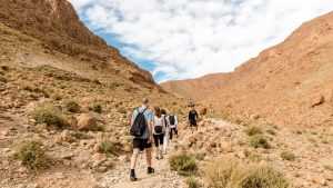
Most trekking routes begin in Imlil Village, the main gateway to the High Atlas.
9 Key Trekking Regions on the Morocco Atlas Map
1. Imlil Valley – The Main Gateway
Located south of Marrakech, Imlil appears on nearly every Atlas range map because it serves as the base for most High Atlas treks and Mount Toubkal climbs.
2. Mount Toubkal Area
The highest peak in North Africa dominates every High Atlas Mountains map.
Typical trek:
-
2–3 days
-
Moderate to challenging
-
High altitude but non-technical in summer
For detailed route planning, see the Complete Travel Guide to Toubkal Trek.
3. Toubkal National Park
This protected area covers much of the central High Atlas.
Highlights:
-
Alpine landscapes
-
Mountain passes
-
Multi-day circuits
It forms the core trekking zone on any map of Morocco Atlas Mountains.
4. Azzaden Valley
One of the most scenic regions in the High Atlas.
Features:
-
Terraced farming landscapes
-
Quiet Berber villages
-
High passes
Often combined with Toubkal routes for longer trekking programs.
5. Ouirgane Valley
Lower elevation and less demanding.
Best for:
-
Easy hiking
-
Relaxed mountain stays
6. Ourika Valley
Closer to Marrakech and ideal for short visits.
You can explore short excursions through day trips from Marrakech.
Highlights include waterfalls at Setti Fatma and scenic riverside trails.
7. M’Goun Massif (Central High Atlas)
Less visited and ideal for experienced trekkers.
Expect:
-
Remote landscapes
-
River trekking sections
-
5–7 day routes
Learn more about the route in the M’Goun trek guide.
8. Middle Atlas Region
North of the High Atlas, known for cedar forests, lakes, and rolling hills. Better suited for nature travel than high-altitude trekking.
9. Anti-Atlas Region
South of the High Atlas and closer to desert landscapes.
Features:
-
Rocky terrain
-
Dramatic geology
-
Quiet exploration
How to Choose the Right Atlas Region
Use a map of Morocco Atlas Mountains based on your goals.
Choose High Atlas if you want:
-
Multi-day trekking
-
A Mount Toubkal climb
-
High-altitude adventure
Choose Middle Atlas if you want:
-
Forest landscapes
-
Easy hiking
-
Cooler temperatures
Choose Anti-Atlas if you want:
-
Remote scenery
-
Desert proximity
-
Quiet travel
For most adventure travelers, the High Atlas offers the best balance of challenge and accessibility.
Best Time for High Atlas Trekking
Spring (March–May) and autumn (September–November) provide the most comfortable trekking conditions.
For seasonal planning, see Best Time to Travel in Morocco.
Summer works well at altitude, while winter requires snow gear and preparation.
FAQ
Where are the Atlas Mountains located in Morocco?
They run diagonally across central Morocco, forming the High Atlas, Middle Atlas, and Anti-Atlas regions.
Which Atlas region is best for trekking?
The High Atlas near Marrakech, especially around Imlil and Mount Toubkal.
How far is the High Atlas from Marrakech?
About 1.5–2 hours by road.
Is Mount Toubkal difficult?
Physically demanding due to altitude but non-technical in summer.
Conclusion
At first glance, the Atlas may seem like one continuous mountain chain. But once you understand the layout on a map of Morocco Atlas Mountains, the differences between regions become clear.
The High Atlas stands out for serious trekking and high-altitude adventure. The Middle Atlas offers forests and lakes, while the Anti-Atlas provides remote desert-mountain landscapes.
If your goal is to truly explore the mountains rather than simply visit them, the High Atlas is where most journeys begin.